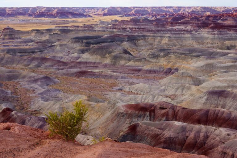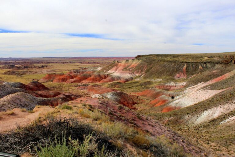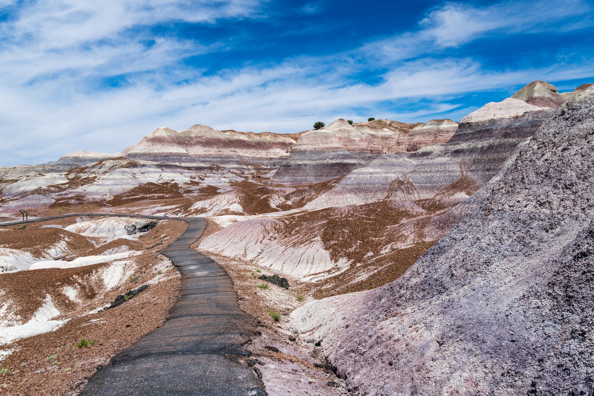
The Blue Mesa Trail is a 1-mile loop in Petrified Forest National Park that drops off a mesa top into hills striped blue, purple, gray and peach.
It takes most people 30 minutes to an hour, and the only hard part is the steep climb back up at the end.
We live in Holbrook, about 45 minutes from the trailhead, so we’ve walked it in every season.
Below, we cover how to get there, what you’ll see, when to go and how to stretch the hike into something longer.
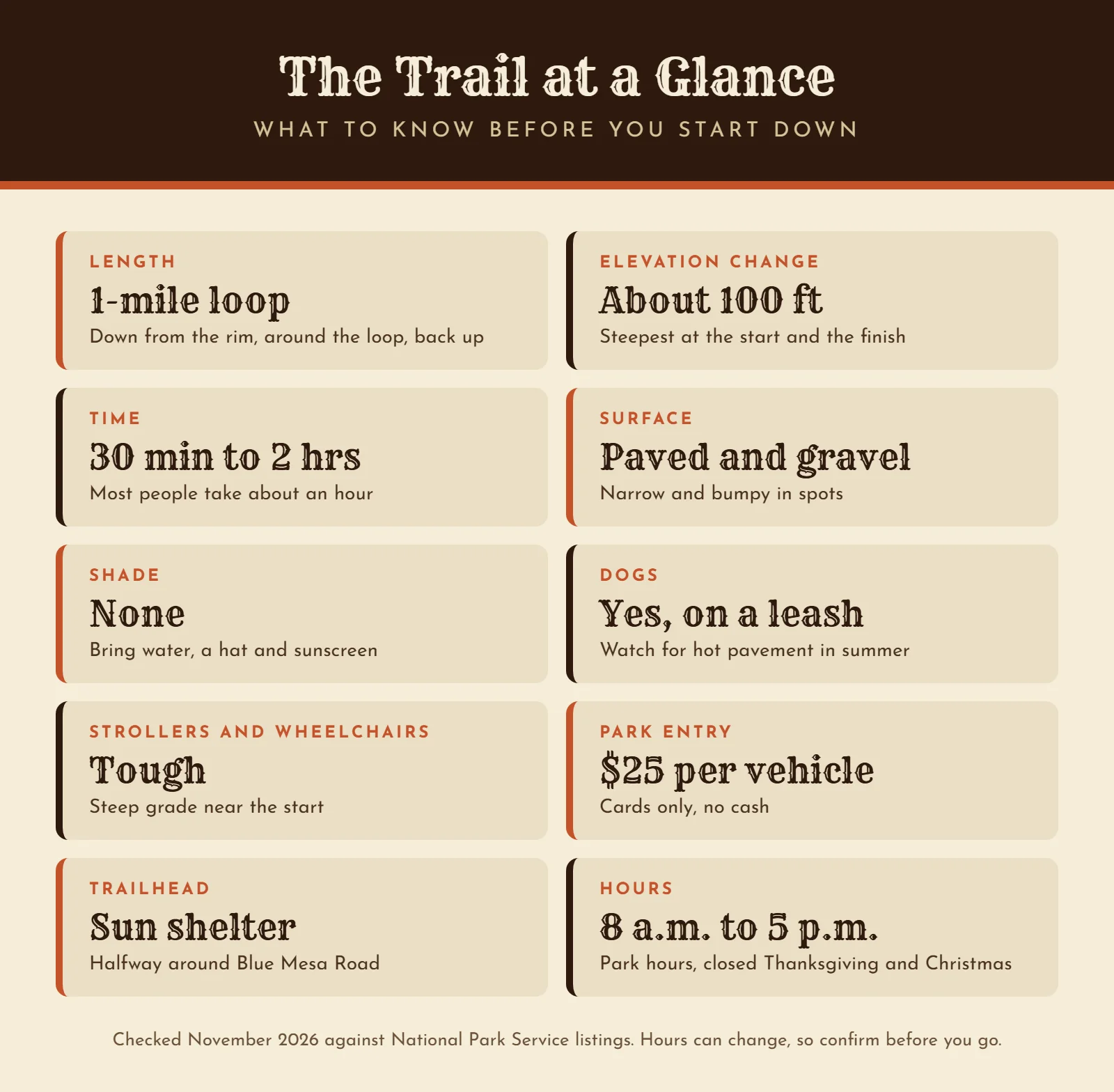
Blue Mesa Trail at a Glance
Here’s the short version before you go. The trailhead sits about halfway through the park, at a sun shelter on Blue Mesa Road.
How Long Does It Take to Hike?
The National Park Service says to plan on 30 minutes to two hours. A steady walker can finish the loop in half an hour.
Still, you’ll want longer. Most people stop every few minutes for photos, and the signs along the trail are worth reading.
Is the Blue Mesa Trail Hard?
Not really. AllTrails rates it easy, with about 114 feet of elevation change.
The catch is how that change happens. The trail starts on top of the mesa and drops down a few switchbacks, so you walk downhill first and pay for it on the way out.
The park sits around 5,400 feet up, too. So if you came from sea level, that last climb can leave you breathing harder than you’d expect.
Where Is the Blue Mesa Trail?
It’s in the middle of Petrified Forest National Park, in northeast Arizona. The trailhead is on Blue Mesa Road, a paved spur off the main park road between the Tepees and Agate Bridge.
Coming from the south entrance, it’s about 15 miles to the trailhead. From the north entrance off I-40, it’s about 18.
Getting There From Holbrook
Holbrook is the closest town to the park’s south entrance. Take U.S. 180 southeast for 19 miles, then follow the park road north.
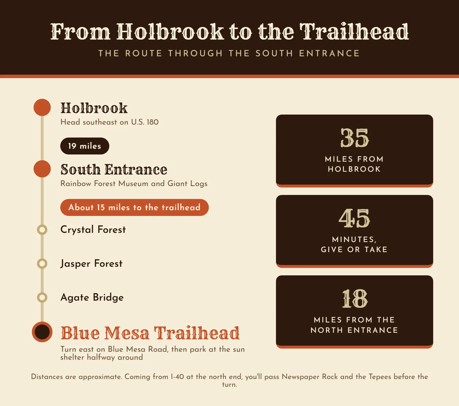
All told, it’s about 35 miles and roughly 45 minutes from town.
If you’re staying here, our guide to Petrified Forest National Park hotels shows where to sleep.
Driving Blue Mesa Road
Blue Mesa Road is a 3.5-mile loop that climbs onto the mesa. It runs one way, with pullouts along the rim where you can look down into the badlands.
Don’t skip those pullouts on the way in. Some of the best views of the striped hills come from up top, before you ever start walking.
Parking at Blue Mesa
The trailhead is halfway around the loop, next to a covered sun shelter. Look for the biggest parking lot on the road.
There are benches, a picnic table and a bike rack.
However, the Park Service doesn’t list restrooms or water at Blue Mesa, so take care of both before you get there.
What You’ll See Along the Trail
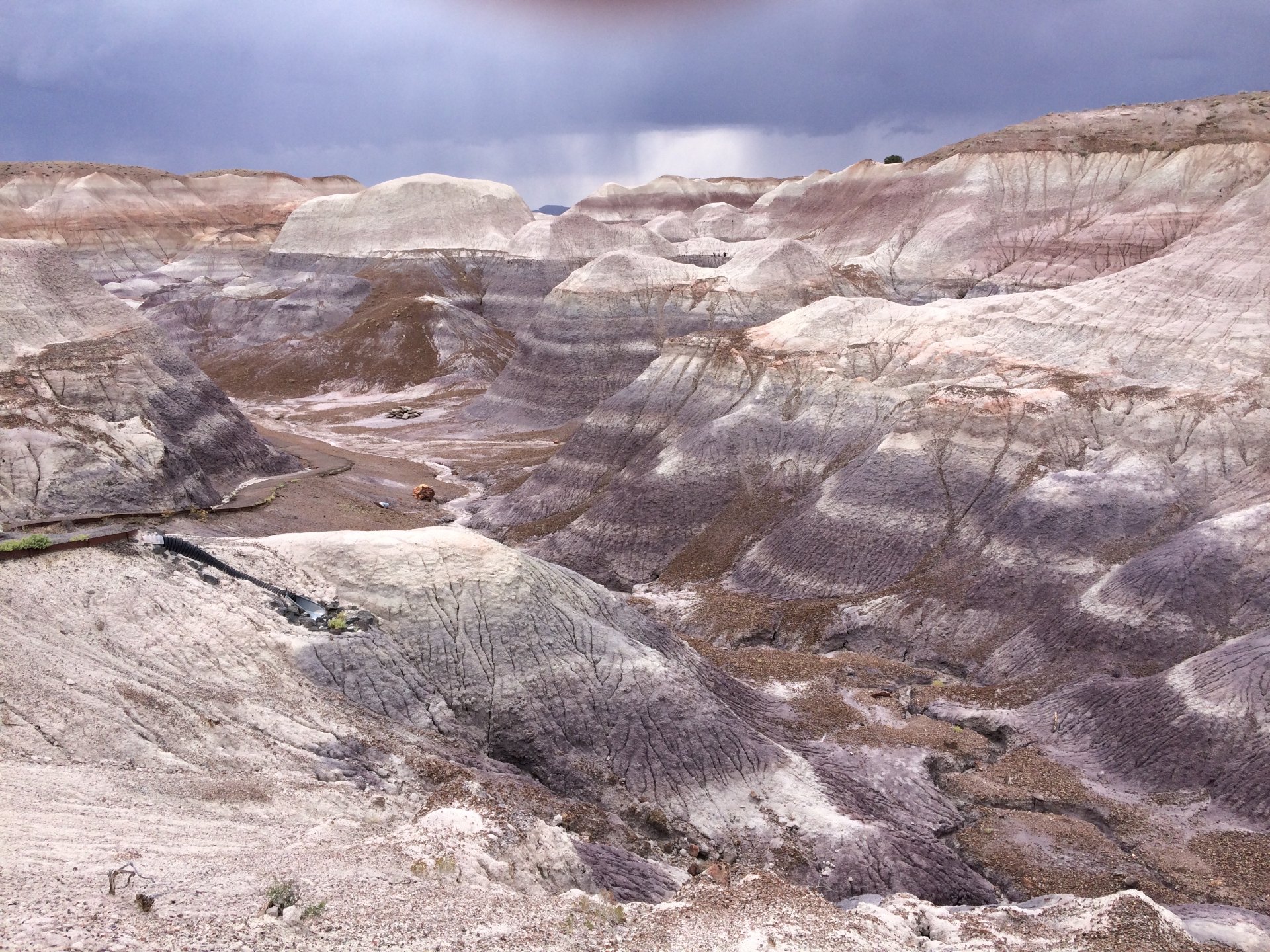
The trail starts on the rim of Blue Mesa, and the colors show up almost right away.
Within a few steps, you’re looking straight down into rows of rounded, striped hills.
The Walk Down Off the Mesa
The first stretch is the steep part. It switchbacks down off the mesa, mostly on pavement, with a couple of benches and overlooks along the way.
The path is narrow and a little bumpy in places. So take it slow, especially if you’re holding a camera.
The Loop Through the Badlands
At the bottom, the trail splits into a loop.
You can go either way, since it comes back to the same spot.
From here, the path is a mix of pavement and packed gravel. It winds between the hills, close enough that you can see the cracked, crusty texture of the clay.
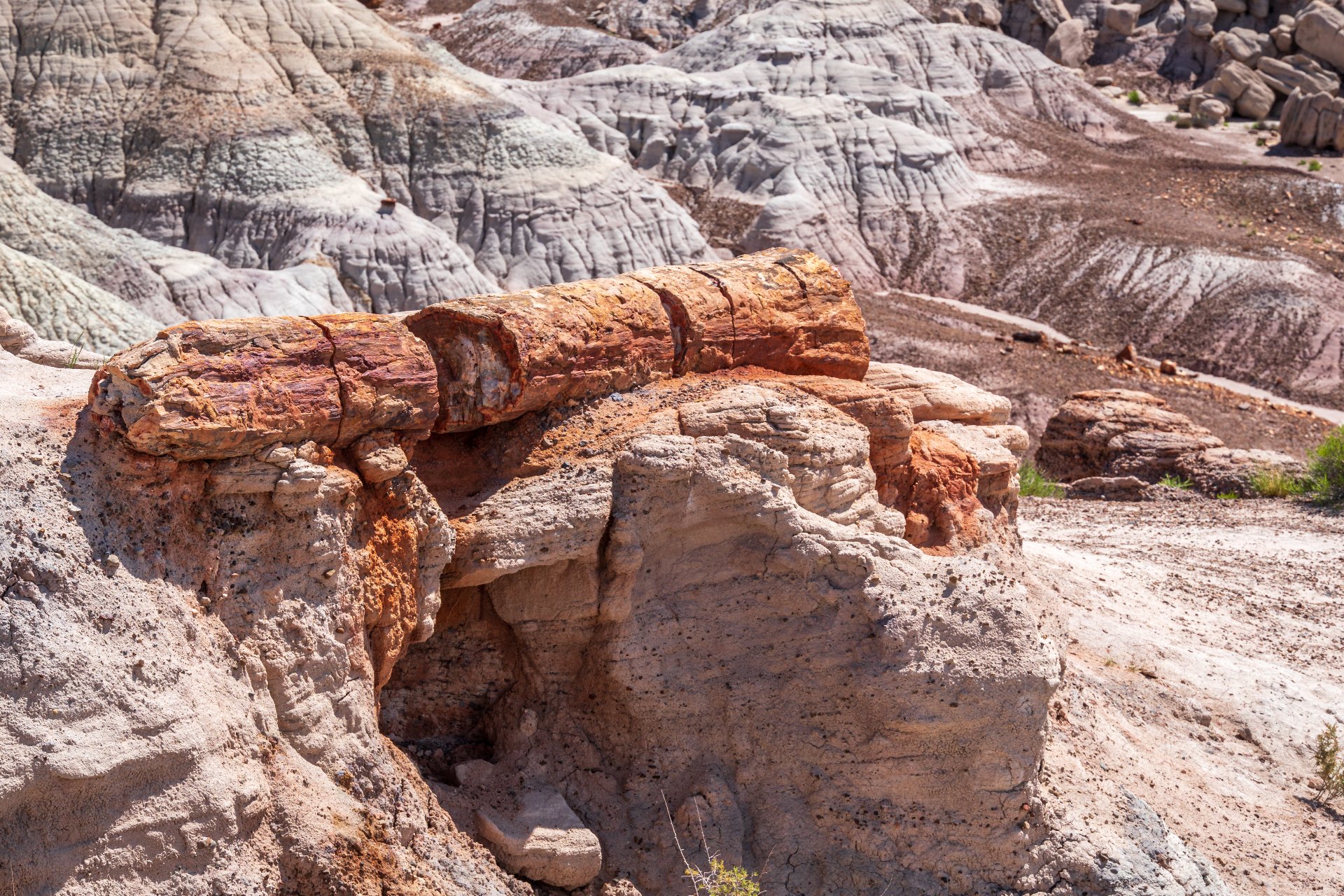
You’ll also pass a lot of petrified wood.
Some logs sit on little pedestals of clay where the ground around them has worn away. The Park Service’s own photo of Blue Mesa shows one balanced on top of a hill at twilight.
Every stripe on those hills is a slice of time, and the trail walks you right through them.
Why the Hills Look Blue
The color comes from bentonite, a clay made from old volcanic ash. Every hill along the trail belongs to a rock layer that shares the mesa’s name, the Blue Mesa Member.
The Park Service’s geology page puts those layers at about 220 to 225 million years old. Back then, this was a wet, swampy floodplain full of rivers.
The stripes are ancient soils. Minerals in each layer give it a different shade, so you get gray, blue, purple and peach stacked on top of each other.
Paleontologists have found plenty of plant and animal fossils in these layers, too.
That’s one more reason to stay on the trail.
Staying Safe on the Blue Mesa Trail
The hills look soft, but they’re fragile.
So stay on the paved and gravel path, even when a side trail looks tempting.
Leave every piece of petrified wood where it is. Taking any of it is against federal law, even a chip the size of a fingernail.
If you want a piece to take home, buy it in town. Our guide to Arizona petrified wood explains where to get it legally.
When It Rains
Bentonite turns slick and gummy when it gets wet. The Park Service warns that footing out here can get treacherous in wet or icy weather.
So if it rained in the last day or so, wear shoes with good tread, or save the hike for later. Check the forecast for the park before you leave town.
Heat and Sun
There’s no shade on the loop. In summer, that sun gets intense, so bring water, a hat and sunscreen even for a short walk.
The climb out is where people struggle. Leave something in your water bottle for it.
Can You Bring Your Dog?
Yes. Pets are allowed on the park’s developed trails, including this one, as long as they’re on a leash.
Just remember the ground heats up fast in summer. If the pavement is too hot for your hand, it’s too hot for paws.
Strollers and Wheelchairs
The Park Service says most of the trail isn’t accessible for mobility devices, mainly because of the steep grade near the start. A sturdy stroller can make it, but you’ll be pushing hard on the way back up.
If walking down isn’t an option, drive the loop road instead. The rim views are almost as good.
When to Hike the Blue Mesa Trail
The trail is open all year, during park hours. Right now, the park is open 8 a.m. to 5 p.m. every day, and closed on Thanksgiving and Christmas.
Hours have run later in some past summers, so check before you go.
Best Time of Day
Go early or late in the day. Low sun makes the stripes pop, while midday light washes them out and the heat is at its worst.
Early morning is also the quietest. Blue Mesa is one of the busiest stops in the park, so an early start means fewer people on the trail and in your photos.
Best Time of Year
Spring and fall are the easiest seasons for this hike. The weather is mild, though spring afternoons can get windy.
Summer is hot, and July through September brings monsoon storms. Winter is cold, but the trail is quiet and you may have the loop to yourself.
Watch It Before You Go
The Park Service filmed the whole Blue Mesa loop, and the sign at the start of the trail has a QR code that links to it. It’s a good way to preview the climb, or to see the trail if you can’t make the walk yourself.
Make It a Longer Hike
If one mile isn’t enough, you’ve got options. The best one starts right off this loop.
The Historic Blue Forest Trail
The Civilian Conservation Corps built this trail in the 1930s to connect the lower and upper Blue Mesa roads. Today it’s an unofficial, off-the-beaten-path route through more badlands, and it joins the Blue Mesa loop at its north end.
It’s longer and rougher, at about 2.7 miles on AllTrails, with loose gravel and slick clay in spots. The Park Service suggests walking sticks, and you’ll want a map.
Is This the Best Hike in Petrified Forest?
For badlands, we think so. Nothing else in the park puts you down inside the colors like this.
For petrified wood, though, Crystal Forest and Giant Logs are better. For big Painted Desert views, walk the rim trail at Kachina Point.
Our Petrified Forest guide shows how to fit several into one day.
Plan the Rest of Your Day
Blue Mesa is a natural middle stop when you drive the park end to end, and the trail only takes about an hour. Just north of it, the Tepees and Newspaper Rock sit along the main road.
Just south, you’ll find Agate Bridge and Jasper Forest. Then Crystal Forest and the Rainbow Forest Museum wrap things up near the south entrance.
Fees and What to Bring
Entry is $25 per vehicle, and the park doesn’t take cash, so bring a card.
If you’re visiting several parks this year, a digital America the Beautiful pass from Recreation.gov covers this one too.
For the trail itself, pack water, sun protection and shoes with grip.
A camera helps, too, because you’ll use it.
Food, Gas and Restrooms
The Painted Desert Visitor Center near the north entrance is closed for renovation until mid-2027. Its restrooms, gas station, gift shop and restaurant are still open, and visitor services have moved to the Painted Desert Inn.
At the south end, the Rainbow Forest Museum is open daily. Otherwise, Holbrook is your best bet for a real meal.
Is the Blue Mesa Trail Worth It?
Yes. In about an hour, the trail at Blue Mesa gives you the most colorful badlands in the park, petrified wood at your feet and a walk almost anyone can manage.
Go early, bring water and save some energy for the climb out. Then, if you’re turning it into a full trip, tell us your dates and our free trip planner will build the rest of your visit around the park.
Photo credits: Blue Mesa Trail and petrified log by dconvertini (CC BY-SA 2.0). Blue Mesa badlands by VALOHAZ (CC0).